Importance of Drone Photography in Real Estate
In the highly competitive Miami real estate market, showcasing properties with compelling visual content has become a crucial element of successful marketing strategies. Drone photography offers an unmatched perspective that captures the full scope and grandeur of a property, giving potential buyers a comprehensive view that traditional ground-level images cannot provide. High-quality aerial shots reveal the property's layout, surrounding landscape, and proximity to key amenities, creating a vivid impression that can significantly influence purchasing decisions.
Drone imagery plays a vital role in highlighting unique architectural features, outdoor living spaces, and the overall curb appeal of homes. When prospective buyers access online listings, images taken from a drone can evoke a sense of scale and luxury, especially for expansive estates, waterfront properties, and developments with impressive outdoor amenities. For real estate agents and property owners, integrating drone photos into listings enhances visual storytelling, making properties stand out amidst a crowded marketplace.
Staging a property with drone footage offers an immersive experience, allowing viewers to virtually explore the property’s surroundings and understand its environment better. This comprehensive perspective reduces ambiguity and provides confidence in the property's offering, ultimately accelerating the sales process. As Miami continues to attract international buyers and investors, the strategic use of aerial imagery becomes an essential component of modern real estate marketing, helping listings reach a wider audience and generate more engagement.

Furthermore, drone photography is instrumental in virtual tours and 3D mappings, providing a seamless experience for remote buyers and investors. This technology bridges geographic gaps, offering an interactive view that closely replicates an in-person visit. As a result, properties garner increased interest and showings, reducing time on market and boosting transaction success rates.
With Miami’s diverse property portfolio—including waterfront estates, luxury condominiums, and commercial spaces—professional drone photography serves as a powerful tool to showcase each property's unique qualities effectively. In a market driven by visual appeal and quick decision-making, mastering drone imagery has become an indispensable element of real estate marketing that benefits agents, sellers, and buyers alike.
Key Equipment and Technology Used by Drone Photographers
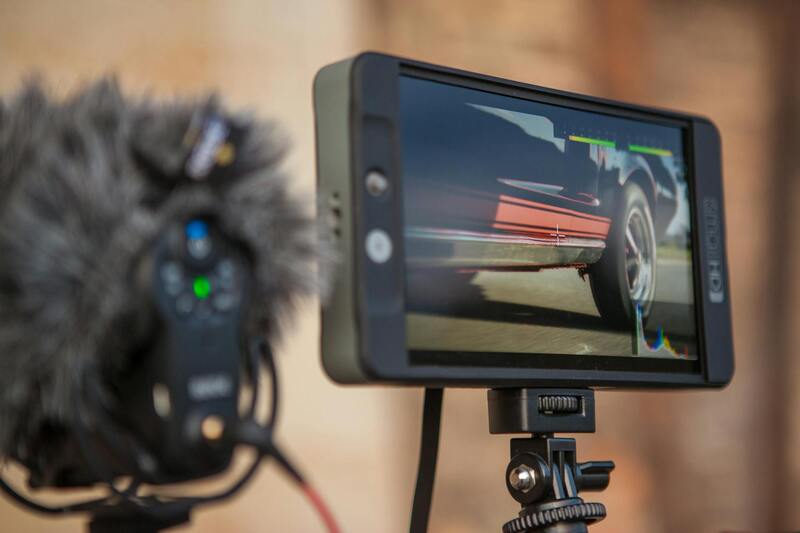
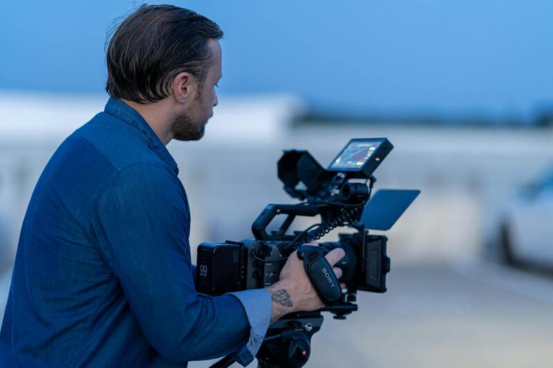
Professional drone real estate photography hinges on the utilization of advanced equipment and cutting-edge technology. High-quality unmanned aerial vehicles (UAVs) serve as the foundation for capturing crisp, stable, and expansive images that highlight a property's most appealing features. These drones are typically equipped with high-resolution cameras capable of capturing detailed aerial shots and videos that can substantially enhance a property's visual appeal.
Beyond basic cameras, many drone operators employ models with gimbal stabilization systems that ensure smooth footage even in challenging wind conditions. This stability results in professional-grade imagery free from jitters or blurs, which is essential for attracting serious buyers. Furthermore, drone operators often use multi-rotor setups for precise maneuverability and fixed-wing drones for extended flight times, allowing comprehensive coverage of large properties or sprawling estates.
In addition to the drones themselves, a variety of ancillary equipment plays a crucial role in producing optimal imagery:
- High-Resolution Cameras: Cameras with 20+ megapixels enable the capture of detailed images suitable for marketing materials.
- Gimbals: These stabilization devices ensure steady shots, essential for creating professional-quality videos and panoramic images.
- Lighting Equipment: Supplemental lighting can be used to improve image clarity during low-light conditions, especially for interior or shaded exteriors.
- Software for Image Stitching and 3D Mapping: Programs such as photogrammetry tools facilitate the creation of detailed 3D models and comprehensive maps of the property and its surroundings.
The integration of these technologies not only enhances image quality but also provides real estate professionals with versatile tools to craft compelling visual narratives of property listings. Modern drone systems also feature GPS-based navigation and obstacle avoidance, which increase safety and efficiency during flights, especially over complex or elevated terrains.
Moreover, the ability to plan flight paths via pre-programmed routes ensures systematic coverage of large properties, optimizing the quality and consistency of captures. This precision allows for a seamless presentation of the property’s layout, surroundings, and key features, making it easier for potential buyers to visualize themselves within the space.
High-spec equipment and sophisticated software solutions collectively enable drone photographers to deliver content that meets the rigorous standards of the Miami real estate market. As properties become more visually driven and technologically sophisticated, utilizing state-of-the-art tools remains fundamental to staying competitive and achieving marketing success.
Legal Regulations and Permits for Drone Photography in Miami
Conducting drone photography for real estate in Miami necessitates adherence to established operational standards that govern the use of aerial devices. Professionals engaged in drone-based imaging must secure appropriate permissions before initiating flight activities. This includes registering the drone with the Federal Aviation Administration (FAA), which involves providing identification details and ensuring the drone meets specific safety standards. Registration helps authorities track and regulate drone operations, fostering safety across the airspace.
Beyond registration, drone operators must obtain specific permits if their flights are to be conducted over densely populated areas or near sensitive infrastructure. These permits often require a detailed flight plan, including the intended flight path, altitude, and operation times. Preparing comprehensive documentation illustrates compliance with operational guidelines designed to minimize risks and ensure public safety.
Professionals seeking to capture high-quality real estate imagery typically work within designated airspace corridors and adhere to strict altitude restrictions to avoid interference with manned aircraft. Utilizing pre-flight risk assessments and mission planning tools helps mitigate hazards and ensures a smooth operational process. Potential drone photographers should also be aware of local restrictions and temporary flight advisories that may impact their scheduled shoots.
By following these official procedures, drone real estate photographers can deliver stunning visual content while maintaining operational integrity within Miami’s airspace. This approach not only complies with regulatory expectations but also reinforces a professional commitment to safety and responsible aerial imaging.
Legal Regulations and Permits for Drone Photography in Miami
Operating drones for real estate photography in Miami requires adherence to a comprehensive set of rules established by local and federal authorities. These regulations are designed to ensure the safety of drone operations while facilitating high-quality aerial imagery. Professionals must secure the appropriate permits before initiating any commercial drone flights and must comply with restrictions related to airspace usage, altitude limits, and flight times.
One critical aspect involves obtaining a commercial drone operator permit, which verifies the operator’s qualification and commitment to following standardized procedures. This process often includes submitting detailed flight plans, demonstrating understanding of safety protocols, and occasionally passing competency tests. Such permits validate that the drone photographer is equipped to manage aerial operations responsibly.
Miami-specific regulations also outline operational boundaries to prevent interference with manned aircraft, especially around airports and busy urban areas. Drone flights are generally restricted to daytime hours and within visual line of sight, ensuring clear visibility of the drone’s position at all times. Enforcing these rules minimizes risks associated with aerial imaging.
 igurecaption> Proper Permitting Ensures Safe and Compliant Drone Photography in Miami
Additionally, drone operators must implement safety guidelines such as avoiding crowded spaces, maintaining a safe distance from structures, and respecting privacy boundaries. These precautions not only facilitate smooth operations but also maintain public trust and uphold the professionalism of the drone photography industry.
Local authorities periodically issue temporary flight restrictions, especially during special events or emergencies, which must be carefully observed by drone professionals. Regularly reviewing updates from Miami’s aviation authority is essential for ongoing compliance.
Working within these regulatory frameworks demonstrates a commitment to responsible aerial imagery, allowing real estate professionals to showcase properties effectively and ethically. Proper licensing and adherence to operational guidelines create a foundation for successful and sustainable drone photography endeavors in Miami.
Legal Regulations and Permits for Drone Photography in Miami
Conducting drone photography in Miami requires adherence to specific operational guidelines and obtaining relevant permits, which serve as a formal acknowledgment of the drone operator's capacity to execute aerial imaging responsibly. These permits are issued by local aviation authorities, ensuring that drone flights are coordinated with existing air traffic regulations and are conducted within designated areas and times.
In Miami, drone operators are expected to familiarize themselves with the city's flight restrictions, especially in proximity to airports, busy urban districts, and protected airspace zones. Such restrictions are put in place to prevent interference with commercial and private aircraft, safeguarding both operations and public safety. Typical operational parameters include a limit to daytime flights, clear visibility requirements, and maintaining line-of-sight contact with the drone throughout the flight.
Obtaining the necessary permits involves providing proof of pilot competency, insurance documentation, and detailed flight plans. These elements verify that the drone operator has the appropriate training to manage aerial operations responsibly. Furthermore, the permits facilitate the planning of flight paths that avoid sensitive areas and minimize potential disturbances to residents and businesses.
Safety procedures form a cornerstone of compliant drone operations. Operators are expected to avoid crowded spaces, keep a safe distance from structures and individuals, and respect privacy boundaries. Implementing these precautions ensures that drone flights are conducted smoothly and contributes to fostering public confidence in aerial imaging practices.
Additionally, regularly monitoring updates issued by Miami’s aviation authorities is crucial. Temporary flight restrictions are frequently enforced during special events, emergencies, or construction activities. Staying informed about these restrictions ensures ongoing compliance and prevents disruptions or violations of operational guidelines.
Many professional drone service providers prioritize obtaining and maintaining all necessary permits, reflecting their commitment to responsible and ethical aerial imaging. This compliance not only enhances the credibility of the drone photographer but also ensures that the property owners, real estate professionals, and other stakeholders can confidently incorporate aerial visuals into their marketing efforts without concerns about procedural issues.
Key Equipment and Technology Used by Drone Photographers
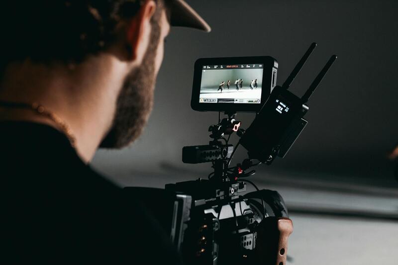
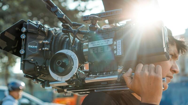
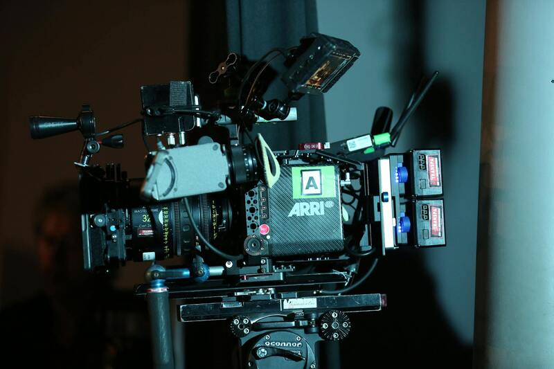
Professionals specializing in drone real estate photography utilize sophisticated equipment to deliver high-quality visuals that effectively showcase properties. The core of their toolkit includes advanced drones equipped with high-resolution cameras capable of capturing detailed images and smooth, stable videos from various altitudes and angles. Many of these drones feature gimbal stabilization systems, which are essential for ensuring crisp, shake-free footage that highlights the property’s best features.
In addition to the drone itself, photographers often employ a range of supplementary tools to enhance their output. This includes external lenses for different focal lengths, filters to manage lighting conditions, and vibration dampers to further improve image stability. High-quality software for post-processing is equally crucial, enabling editors to adjust color balance, brightness, contrast, and remove distortions, thereby producing polished imagery that aligns with client branding.
Camera specifications play a vital role; sensors with larger sizes and higher megapixel counts help capture sharper images with more detail, which translate into compelling property presentations. For video, 4K resolution has become standard, allowing for high-definition virtual tours that impress potential buyers.

Furthermore, drone operators often use advanced flight planning software to optimize flight paths, ensuring comprehensive coverage of the property while avoiding obstacles and restricted zones. Many employ remote control systems with real-time video feeds, giving operators precise control over the camera angle and orientation. Batteries with extended flight times and quick-swapping capabilities are also standard, allowing for efficient shooting sessions that maximize time in the air.
Legal Regulations and Permits for Drone Photography in Miami
Conducting drone photography for real estate in Miami involves adherence to specific operational guidelines governed by local authorities. Securing the necessary permits involves a detailed process, including submitting operational plans, safety protocols, and sometimes proof of operator certification. This process ensures that aerial activities are coordinated with other airspace users and adhere to defined safety standards.
Permits often specify designated flying zones, maximum altitude limits, and restrictions during certain times or events. These measures are designed to prevent interference with manned aircraft operations and safeguard public spaces. Compliance with such restrictions is maintained through regular communication with Miami’s aviation authorities and staying informed of temporary flight advisories.
Professional drone operators routinely update their compliance documentation and renew permits as necessary, demonstrating their commitment to responsible operation. This meticulous approach is vital, especially when capturing images over sensitive or densely populated areas, ensuring that all activities are conducted smoothly without disruption.
In addition, drone operators often engage in continuous training on the latest safety practices and technological advancements. This ongoing education helps maintain a high standard of professionalism and ensures that photorealistic imaging aligns with current operational policies.
Legal Regulations and Permits for Drone Photography in Miami
In Miami, conducting drone-based real estate photography involves adhering to specific procedural requirements aimed at ensuring safe and responsible aerial operations. Communication with local aviation authorities often requires operators to submit detailed operational plans that outline flight paths, altitude ranges, and safety measures. These plans are thoroughly reviewed to prevent interference with other airspace users, particularly in densely populated urban environments.
Securing necessary permits typically involves demonstrating compliance with established safety standards, which may include proof of operator certification and comprehensive risk assessments. The permit application process also underscores the importance of clearly defined flight zones and altitude restrictions, often tailored to specific project locations. These restrictions are designed to minimize disturbance to local communities and to protect public spaces, especially when operating near residential neighborhoods, commercial areas, or sensitive wildlife habitats.
Operators are expected to maintain open channels of communication with Miami’s aviation authorities throughout the project. This ongoing dialogue facilitates awareness of temporary flight restrictions, such as those related to public events or emergencies. Furthermore, professional drone operators continually update their documentation and renew operational permits to reflect current practices, incorporating the latest safety protocols and technological updates.
Commissioning drone imagery for real estate ventures also requires attention to environmental sensitivities and community impact. Proper planning and regulatory compliance help ensure that aerial photography activities are smooth, unobtrusive, and contribute positively to the property’s marketing efforts. The process of obtaining permits and adhering to operational guidelines not only guarantees regulatory adherence but also bolsters a photographer’s reputation for responsible and professional service delivery.
Best Practices in Drone Composition and Photography for Real Estate
Effective drone photography hinges on mastering composition principles tailored to real estate marketing. Key elements include selecting optimal vantage points that highlight the property’s most attractive features, such as expansive lawns, architectural details, or unique landscape elements. Utilizing a variety of angles and perspectives encourages potential buyers to see the full scope and context of the property.
- Optimal Flight Altitudes: Maintaining heights that balance capturing expansive property views while ensuring detail clarity.
- Lighting and Time of Day: Scheduling shoots during golden hour ensures warm, inviting imagery with minimized shadows.
- Proper Framing and Composition: Applying the rule of thirds and ensuring the horizon is level enhances visual appeal.
- Incorporation of Landscaping: Highlighting outdoor amenities such as pools, gardens, and patios can significantly boost marketing impact.

Moreover, maintaining consistent image quality across all shots is essential. This involves calibrating camera settings, ensuring stable flight paths, and employing post-processing techniques for color correction and image enhancement. Professional drone photographers often utilize high-resolution cameras and gimbals to achieve sharp, distortion-free images that faithfully represent the property.
By applying these best practices, drone operators can produce compelling visual narratives that resonate with prospective buyers, empowering real estate agents to position properties more effectively within competitive markets. The goal is to combine technical precision with artistic insight, creating imagery that not only informs but also captivates viewers.
Advancing Drone Photography with Professional Editing and Post-Processing Techniques
To maximize the visual impact of drone imagery in real estate marketing, professional editing and post-processing play a crucial role. Drone real estate photographers in Miami employ a suite of advanced editing tools to refine their images, ensuring that every shot highlights the property's best features while maintaining authenticity. These techniques include color correction, contrast enhancement, and sharpening to produce vibrant, clear images that attract potential buyers. Adjusting exposure levels helps balance brightness across different areas of the photograph, especially in scenes with challenging lighting conditions, such as interiors or shaded outdoor spaces.
Beyond basic adjustments, high-level professionals utilize specialized software to correct lens distortions caused by wide-angle lenses commonly used in drone cameras. This correction ensures straight lines and proper proportions, preserving the realism of aerial views. Clipping and retouching are also performed to eliminate distracting elements, such as power lines, nearby vehicles, or unnecessary objects in the frame, thereby emphasizing the property's aesthetic appeal.
In addition, drone images are often merged into HDR (High Dynamic Range) composites to produce well-exposed, richly detailed photos that accurately depict both the shadows and highlights of outdoor scenes. This approach is especially effective in capturing the full range of lighting in properties with extensive glass features or complex outdoor environments. Post-processing also extends to creating panoramic images or virtual tours, which serve as immersive experiences that draw prospective buyers deeper into the property's landscape and layout.
Implementing these professional editing practices ensures that the aerial imagery not only stands out but also provides an honest depiction of the property, building trust with viewers. When combined with high-quality drone footage, these images can significantly enhance online listings, brochures, and virtual walkthroughs, ultimately accelerating the sales process for Miami real estate professionals.
